The Real Estate Industry in the city of Hyderabad is at its peak considering the number of settlements in every developing area. Furthermore, Hyderabad is an IT hub, so many people from around the country and abroad are settling in the city to build a successful career.
Considering this, the Telangana Government, through HMDA has executed the HMDA Master Plan that contains information on the different HMDA zones, classified based on their compatible activities. HMDA Land use Zoning is a method of urban planning in which the government divides land into jurisdictions called zones. Zoning classifications can include residential, commercial, agricultural, industrial, or hotel/hospitality, among other more specific uses.
The Metropolitan Development Plan 2031 accounts for 184 lakhs of people, 65 lakhs of workers, and the current development trends the inner Ring Road, Outer Ring Road, and radial roads. To encourage balanced development in the Hyderabad Metropolitan Region, the plan proposed a radial-concentric structure of urban development. A hierarchy of circulation networks is designed as part of the Peri-Urban Zone to meet the people’s current and future travel needs.
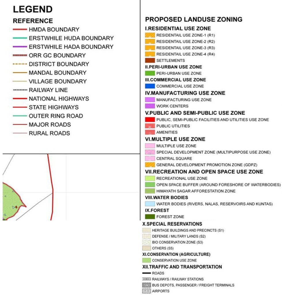
Landuse zones are divided into 12 in HMDA’s Master Plan
1. Residential Use Zone
- Residential Zone-1 (Urban Areas Contiguous to Growth Corridor): Residential zone corresponding to the contiguous urban areas outside the Growth Corridor, where the detailed design of roads and zoning is proposed.
- Residential Zone-2 (Urban Nodes): It is located within non-contiguous urban areas, where detailed plans for roads and different urban uses are proposed.
- Residential Zone-3 (Urban Centers): The proposed Land Use Plan identifies the remaining urban centers, as well as the areas around them. Currently, no detailed planning is proposed herein, and all identified centers/areas are classified as Residential Land Use Zones.
- Residential Zone-4 (All Rural Settlement): Village Settlement (Gramkantham) and the existing rural built-up area are designated as Residential Zone-4 in the proposed plan. The zone shall also encompass an additional 300-meter-wide belt outside the Gramkhantam boundary to accommodate the natural expansion of settlements.
2. Peri-Urban Use Zone
Peri-urban zones are designated areas surrounding identified ‘Urban Areas Contiguous to Growth Corridors’ and ‘Urban Nodes’ in the proposed Metropolitan Development Plan.
3. Commercial Use Zone
Zones designated as Commercial Use Zones and Commercial Strips in the proposed Land Use Plan. It will be beneficial for commercial settlements in the future ahead.
4. Manufacturing Use Zone
These zones are designated by the proposed plan for use as manufacturing zones only. No other reason will be registered or considered other than manufacturing purposes.
5. Public, Semi-Public Facilities, and Utilities Use Zone
Areas designated as Public or Semi-Public Facilities and Utilities Zones in the proposed Land Use Plan and sites specifically designated for such public or semi-public use.
6. Multiple Use Zone
This area has been designated as a Multiple Use Zone in the proposed Land Use Plan and areas where Transit-Oriented Development is allowed.
7. Recreation and Open Space Zone
Recreational Use Zone: Areas designated as open space recreation in the proposed land use plan and sites designated as parks, playgrounds, and exhibition grounds.
Open Space Buffer (Around foreshore of water bodies): There are specific areas that are designated as Open Space Buffers around the Water Bodies Use Zone containing various types of existing water bodies.
8. Water Bodies
Water Body Zones generally include rivers, streams, lakes, and tanks. In the case of perennial water bodies, the boundary has been established by the Full Tank Level / High Flood Level as indicated on relevant maps, covering both perennial and non-perennial parts.
9. Forest Zone
The Forest Department will notify all Reserved Forests. Unless specifically approved by the Forest Department, no activity other than forest and greenery will be permitted in this zone.
10. Special Reserve Zone
This zone focuses on heritage structures, defense / military lands, and bio-conservation areas.
11. Conservation (Agriculture) Use Zone
Conservation (Agriculture) Use Zones are designated in areas beyond the Peri-Urban Zone, which covers most of the remaining area of the Hyderabad Metropolitan Region.
12. Traffic & Transportation Use Zone
This zone contains all of the major roads within the Metropolitan Development Plan, and the site is specifically designated for related facilities. Such as railways, airports, bus depots, truck terminals and parking lots, logistics hubs, and other uses.